

NYC Open Data records all 311 service requests in New York City from 2010 to the present. The 311 number provides access to non-emergency municipal services and is commonly used to report issues such as loud noise, illegal parking and disruptions to public services / utilities etc.
The 311 Requests Map shows 311 requests made in the last 7 days. The maps uses the SODA API to retrieve the last seven days of 311 requests and displays them on a Leaflet map using Stamen's Watercolor map tiles. The data shown on the map can be filtered by agency and type of complaint.

The NYC Rat Map is another Leaflet.js powered map, this one shows the latest reports of rat sightings in New York City. The map shows the locations of all rat sightings in the city since 5/29/2014. If you select a marker on the map you can view details about the date of the sighting, the environment of the sighting and the exact address.
The NYC Rat Map uses Dave Leaver's Marker Clusterering plug-in for Leaflet. The map also includes a heat-map view of rat sightings in the city.

New York has set a 'Vision Zero' goal, to end traffic accident deaths and injuries on the city's roads. To help achieve this aim the City of New York has released a map, Vision Zero View, which shows detailed information on traffic injury and fatality crashes within New York.
The map has two main views; a visualization of New York's traffic accidents and a visualization of the city's attempts to make the streets safer. The 'Crashes' view allows users to visualize the locations of pedestrian,cycling and car injuries and fatalities. This map view includes a timeline which allows you to filter the results shown on the map by year.

The Public Advocate for the City of New York has released an interactive map, The NYC Landord Watchlist, which maps the city's most poorly managed buildings.
The map uses data from the Department of Housing Preservation and Development to list over 6,800 buildings across New York. You can search the map by address and by borough. If you select a property listed on the map you can view the number and type of violations it has received.
The map itself was created using Mapbox but also includes small static Google Street View images of each building listed.

Every Demolition in Manhattan is an animated Google Map showing every demolition that has taken place in Manhattan in the past eleven years. The data for the map comes from the NYC Department of Buildings.
When you load the map animated markers appear on the map to show the location of the demolitions. A time-line beneath the map shows the progress of the animation and indicates the year currently displayed on the map.
Every Demolition in Manhattan uses the Google Maps API circle object for the demolition markers. The circle object in the API allows you to define the opacity of the circle's fill color. Every Demolition in Manhattan uses the custom opacity settings to good effect, to fade in and out each demolition marker during the playback of the animation.

The New York Police Department's NYC Crime Map provides crime information down to the nearest intersection.
The map allows users to view crime data for any month since January 2014 and to filter the results by type of crime. If you zoom in on the map you can view the data by individual incidents of crime or as a heat map. If you search for a location it is also possible to compare the local crime data with crime in the city as a whole.
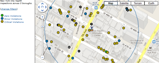
The NYC BigMaps uses the Your Mapper map creation tool to map restaurant inspections and 311 service calls in New York City. The restaurant inspections map displays New York City Department of Health inspections across 5 boroughs since Jan 2008.
You can search the map by category, date range, keyword, and location. The map then displays restaurants on the map at the location you searched. Green map markers indicate restaurants with no health violations.

The New York World has mapped the New York State Department of Agriculture and Markets supermarket inspections from January 2008 to July 2013.
Inspectors visit every grocery store at least once a year. The New York World has mapped all the supermarkets that had 'critical deficiencies' flagged in the inspections. Users can search the map by neighborhood, zipcode or address to find the local supermarkets near them that have been shown to have issues deemed as "an immediate threat to the public health and welfare."
No comments:
Post a Comment