

Fluid Forms produce a number of user designed cartography / geography inspired products, including clocks, bowls, pendants and lamps.
Customers can create their own designs for each of the products by selecting locations from a map. The site uses both OpenStreetMap and Google Maps as tools for selecting your favorite locations. When you have chosen your location on the map Fluid Forms will then 3d print your chosen cartographic product.
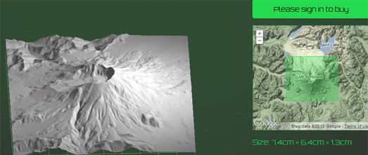
Have you ever dreamed of owning your own 3d scale model of the Grand Canyon or the Matterhorn? Well thanks to the Terrainator you now can.
The Terrainator uses Google Maps to help you select your favorite area of terrain. It then creates an accurate scale model and uploads it to Shapeways, ready for 3D-printing. The models are scaled so that the base is 45cm2. The cost of the model depends on the volume of material required to make the model. Flatter models are therefore cheaper than mountainous areas, although they are much less fun.
Currently you can buy models from terrain in the western USA, from the UK and from the Alps.
No comments:
Post a Comment