
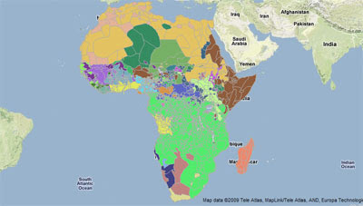
This Google Map mashup contains an amazing amount of data about the African continent. AfricaMap has been developed by the Center for Geographic Analysis at Harvard University to make spatial data on Africa easier for researchers to discover and explore.
The incredible amount of data on this map is organised into three main categories: View, Map Layers and Places. The three categories can be accessed via tabs at the top of the map.
The View tab is the one to select to view the map and to select from the different map types. The Map Layers tab is the main tab for selecting what data you wish to see presented on the map. The data is then sub-categorised into Base Mapping, Economic, Environmental, Ethno Linguistic, Ethno Classification, Harvard Collections, Historic Maps 1800 to 1950, Historic Maps 1800 to 1950, Local Projects, Period Maps, Place Names & Political and Population.
The Places tab allows users to access Place Name information across the continent by category. The database contains hundreds of Place Types for Africa (i.e. administrative divisions, populated places, farms, streams, etc.).
________________
2 comments:
i just wanted to see a map of Africa from the colonial period circa 1950-found this site totslly useless for the purpose-it just took me round in circles and ended up nowhere.
If you click on the Map Layers tab and then tick one of the layers in the Historic Maps 1800-1950 you might find some maps you are interested in.
Post a Comment